Chatham County, Georgia, United States涨潮退潮时间

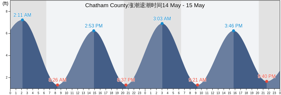
星期三 24 四月 2024, 02:59 EDT (GMT -0400). 目前这股潮汐正在下降Chatham County正如您在潮汐图中看到的,最高潮8.2ft在22:05和最低潮0.33ft在03:51 单击此处查看本周Chatham County的潮汐时间.

下一个涨潮

下一个涨潮是在
09:46

下一个退潮

下一个退潮是在
03:51

Chatham County潮汐表

Chatham County涨潮退潮潮时间
Chatham County潮汐表 日出和日落
第一潮水 第二次潮水 第三潮水 第四潮水
周三 2403:51
0.33 ft
09:46
7.22 ft
15:47
0.33 ft
22:05
8.2 ft
06:45 20:00
周四 2504:29
0.33 ft
10:20
7.22 ft
16:23
0.33 ft
22:37
8.2 ft
06:44 20:01
周五 2605:07
0.33 ft
10:56
6.89 ft
17:00
0.33 ft
23:13
8.2 ft
06:43 20:02
周六 2705:47
0.33 ft
11:36
6.89 ft
17:40
0.66 ft
23:56
7.87 ft
06:42 20:02
周日 2806:31
0.66 ft
12:24
6.56 ft
18:24
0.66 ft
06:41 20:03
周一 2900:48
7.87 ft
07:19
0.66 ft
13:20
6.56 ft
19:16
0.66 ft
06:40 20:04
周二 3001:48
7.55 ft
08:15
0.98 ft
14:22
6.56 ft
20:17
0.98 ft
06:39 20:04

Chatham County今天去钓鱼的最佳时机 最佳捕鱼日

主要捕鱼时间

从07:27至09:27

经过月亮反面 (月亮下)

从19:57至21:57

月亮经过 (月亮上)

小渔时间

从06:25至07:25

月落

从20:27至21:27

月初

单击此处查看本周Chatham County的钓鱼时间.

Chatham County当前天气

清除/晴朗

天气

云盖0%
温度

温度

63°F
最低限度60°F/最大限度69°F
风

11英里/小时
风阵19英里/小时
湿度

湿度

61%
露点49°F

单击此处查看Chatham County的本周天气

今天Chatham County的天气

太阳升起的时间会是06:45和太阳落下的时间会是20:00。这里将有13小时和15分钟的阳光时间和平均温度是67°F。目前的水温是70°F和平均水温是70°F.

Chatham County今天的天气
0 h 3 h 6 h 9 h 12 h 15 h 18 h 21 h 24 h
清除/晴朗清除/晴朗清除/晴朗晴晴局部多云局部多云局部多云局部多云
63°F66°F67°F66°F67°F69°F67°F67°F67°F

单击此处查看Chatham County的本周天气

更多Chatham County的潮汐和海洋信息

地区和城市内Chatham County, Georgia, United States

2nd Street (Tybee Island)Fort Mcallister (Ogeechee River)Raccoon Key
610 Statute Mile MarkFort McAllister Ogeechee RiverRange A Light Bear River
Beach HammockFort PulaskiRomerly Marsh Creek
Bear River EntranceFort Pulaski 1.8 miles aboveS C L Rr Bridge
Bloody Point (Daufuskie Island)Fort Pulaski 4.8 miles aboveS.C.L. Rr. Bridge
Bloody Point Daufuskie IslandGood Hope Landing (South Of)Savannah
Bloody Pt. 0.5 mile north of New RiverGood Hope Landing South OfSavannah Bull Street
Bloody Pt. 0.5 mile west of New RiverGreys IslandSavannah River Entrance (between jetties)
Bradley Point (Bradley River)Hargray Pier (Daufuskie Island)Savannah River Entrance Fort Pulaski
Bradley Point Bradley RiverHargray Pier Daufuskie IslandSavannah Sheraton Resort Hotel
Bradley Point NNE ofHighway Bridge (Ogeechee River)Savannah southeast of highway bridge
Bull River 2 miles below hwy. bridgeHighway Bridge Ogeechee RiverSeaboard Coast Line Railroad
Burnside Island SE of Burnside RiverIsle of HopeSkidaway Island
Burntpot Island west of Skidaway RiverIsle of Hope (Skidaway River)Skidaway Island N End Wilmington River
Butter Bean BeachIsle of Hope City SE of Skidaway RiverSkidaway Narrows
Cane Patch Creek EntranceIsle of Hope City Skidaway RiverSkidaway River north entrance
Coffee Bluff (Forest River)Isle Of Hope Skidaway RiverSouth Channel western end
Coffee Bluff Forest RiverJoe's CutSouth of Kilkenny Creek Entrance
Cook Landing CemeteryJoes Cut Wilmington RiverSouth Ossabaw Island Bear River
Daufuskie Landing (Daufuskie Island)Kilkenny Club (Kilkenny Creek)St. Catherines Sound Entrance
Daufuskie Landing Daufuskie IslandKilkenny Club Kilkenny CreekThunderbolt
Daufuskie Landing Light south ofKing Island west ofThunderbolt SE of Wilmington River
Delegal Creek MarinaKings Island Channel Savannah RiverTurnbridge Landing (Salt Water Creek)
Doughboy IslandLazaretto Creek Entrance N of Bull RiverTurnbridge Landing Salt Water Creek
Dutch Island SE of Skidaway RiverLittle Back River Hwy. 17 Back River S.C.Tybee Creek Entrance
Egg IslandsLittle Don Island east of Vernon RiverTybee Island
Elba Island Cut NE of Savannah RiverLittle Ogeechee River EntranceTybee Light
Elba Island NE of Savannah RiverLittle Ogeechee River Entrance north ofTybee South End Sand Bar
Elba Island west of Savannah RiverLittle Wassaw Island SW ofVernon R. 1.2 miles S of Possum Point
Entrance off Beach HammockLong Island NNE of Skidaway RiverVernon View
Entrance off Wassaw IslandLong Island south of Skidaway RiverVernon View (Burnside River)
Fields Cut (Wright River)McQueen Island CutWalls Cut Turtle Island
Fields Cut Wright RiverMontgomeryWassaw Island N of E end Wassaw Sound
Fig Island north of Back RiverMontgomery Vernon RiverWassaw Island SSW of
Florida Passage (Bear River)North EntranceWhitemarsh Island
Florida Passage (Ogeechee River)North of Big Tom Creek EntranceWilmington Island
Florida Passage (south)Northwest of Newell Creek EntranceWilmington Island SSE of Bull River
Florida Passage Bear RiverOatland Island north tipWilmington R. 0.5 mi. S of Turners Creek
Florida Passage N of Ogeechee RiverOdingsell River EntranceWilmington R. ent. south channel
Florida Passage Ogeechee RiverPelican PointWilmington River ent. off Cabbage Island
Fort JacksonPigeon Island SSE of Skidaway RiverWright R. 0.2 mile above Walls Cut
Fort Mc Allister Ogeechee RiverPort Wentworth 0.2 mile above