ZH
°F
更改尺寸
Meters
Feet
度
°F
公里小时
英里/小时
节
am/pm
24-hour
您的设置已更新
改变语言
Deutsch
Español
Italiano
Nederlands
中文
English
Français
日本語
Português
今天
7天
天气
钓鱼时间表
海水温度
United States
潮汐
Maryland
潮汐
Somerset County
潮汐
Somerset County海水温度
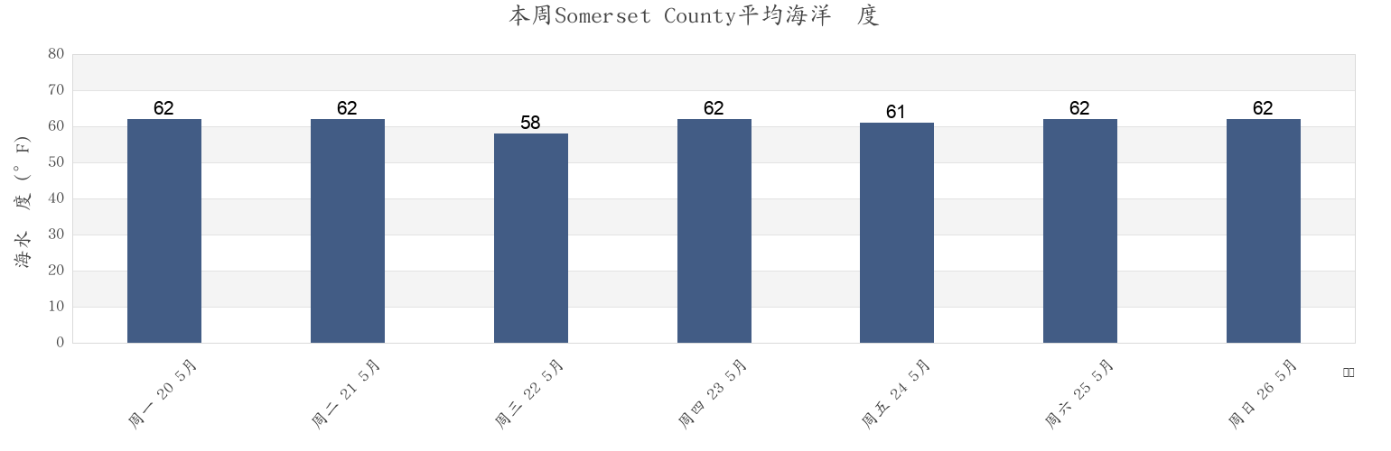
本周Somerset County海温
更多Somerset County的潮汐和海洋信息
今天
7天
天气
钓鱼时间表
地区和城市内Somerset County, Maryland, United States
Ape Hole Creek (Pocomoke Sound)
Ewell Smith Island
Pocomoke R. 0.5 mile below Shelltown
Ape Hole Creek Pocomoke Sound
Fishing Bay Entrance at Buoy 2
Princess Anne
Big Annemessex River Entrance
Frog Point 1.6 miles south of
Raccoon Point
Bishops Head
Great Shoals Light (Monie Bay)
Roaring Point
Bishops Head Hooper Strait
Great Shoals Light Monie Bay
Roaring Point WSW of Nanticoke River
Chance
Holland Island Bar Light
Sandy Point Nanticoke River
显示更多地点
Clump Island 2.5 n.mi. west of
Hooper Strait at Buoy 4
Saxis (Starling Creek Pocomoke Sound)
Colburn Creek (Big Annemessex River)
Janes Island Light 2.3 n.mi. NNE OF
Saxis Starling Creek Pocomoke Sound
Crisfield
Kedges Strait Buoy '4'
Sharkfin Shoal Light
Crisfield (Little Annemessex River)
Kedges Strait Buoy 4
Shelltown
Crisfield Little Annemessex River
Long Point (Big Annemessex River)
Smith Point Light 6.7 n.mi. east of
Dames Quarter Creek
Long Point 2.0 n.mi. northeast of
Solomons Lump Light
Deal Is. 0.6 n.mi. W. of at Bouy 14
Long Point and Nanticoke Point between
Teague Creek (Manokin River)
Deal Island
Long Point Big Annemessex River
Teague Creek Manokin River
Ewell (Smith Island)
Manokin R. Ent. 1.1 n.mi. E of Drum Pt
Victor Point 0.8 mile southwest of
附近的潮汐Somerset County
Teague Creek (Manokin River)
Big Annemessex River Entrance
Teague Creek Manokin River
Manokin R. Ent. 1.1 n.mi. E of Drum Pt
Long Point Big Annemessex River
Long Point (Big Annemessex River)
Colburn Creek (Big Annemessex River)
Raccoon Point
Janes Island Light 2.3 n.mi. NNE OF
Deal Island