ZH
°F
更改尺寸
Meters
Feet
度
°F
公里小时
英里/小时
节
am/pm
24-hour
您的设置已更新
改变语言
Deutsch
Español
Italiano
Nederlands
中文
English
Français
日本語
Português
今天
7天
天气
钓鱼时间表
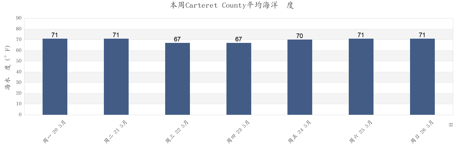
海水温度
United States
潮汐
North Carolina
潮汐
Carteret County
潮汐
Carteret County海水温度
本周Carteret County海温
更多Carteret County的潮汐和海洋信息
今天
7天
天气
钓鱼时间表
地区和城市内Carteret County, North Carolina, United States
Approach
Fort Macon (Uscg Station)
North River Bridge
Atlantic Beach
Fort Macon 0.2 mile NE of
Pettiford Creek Bay
Atlantic Beach Bridge
Fort Macon 0.6 mile SE of
Pine Knoll Shores
Atlantic Beach Triple S Pier
Fort Macon Uscg Station
Portsmouth Island
Beaufort
Gallant Channel
Radio Island E of
Beaufort (Taylor Creek)
Harkers Island
Salter Path
显示更多地点
Beaufort Inlet Channel Range
Harkers Island Bridge
Sea Level
Beaufort Taylor Creek
Indian Beach
Sea Level Core Sound
Bird Shoal SE of
Lenoxville Point
Shackleford Banks 0.8 mile S of
Broad Creek
Middle Marshes S of
Shackleford Point NE of
Cape Carteret
Money Island
Shell Point
Cape Lookout (ocean)
Morehead City
Shell Point (Harkers Island)
Cape Lookout Bight
Morehead City Harbor
Shell Point Harkers Island
Carrot Island
Morehead City RR. bridge N of
Spooner Creek
Cedar Point
Morehead City S of
Spooners Creek
Channel Marker Lt. 59
N C State Fisheries
Sugarloaf Island 0.2 mile S of
Coral Bay (Atlantic Beach)
N.c. State Fisheries
Tombstone Point 0.1 mile E of
Coral Bay Atlantic Beach
Newport
Triple Ess Marina (Bogue Sd.)
Core Creek Bridge
Newport Marshes E of
Triple Ess Marina Bogue Sd.
Core Sound
Newport Marshes SE of
Triple S Marina Bogue Sd
Emerald Isle
Newport River (yacht Club)
Turning Basin
附近的潮汐Carteret County
Core Sound
North River Bridge
Core Creek Bridge
Sea Level Core Sound
Sea Level
Newport River (yacht Club)
Harkers Island Bridge
Lenoxville Point
Harkers Island
Newport Marshes E of