ZH
°F
更改尺寸
Meters
Feet
度
°F
公里小时
英里/小时
节
am/pm
24-hour
您的设置已更新
改变语言
Deutsch
Español
Italiano
Nederlands
中文
English
Français
日本語
Português
今天
7天
天气
钓鱼时间表
海水温度
United States
潮汐
South Carolina
潮汐
Charleston County
潮汐
Charleston County海水温度
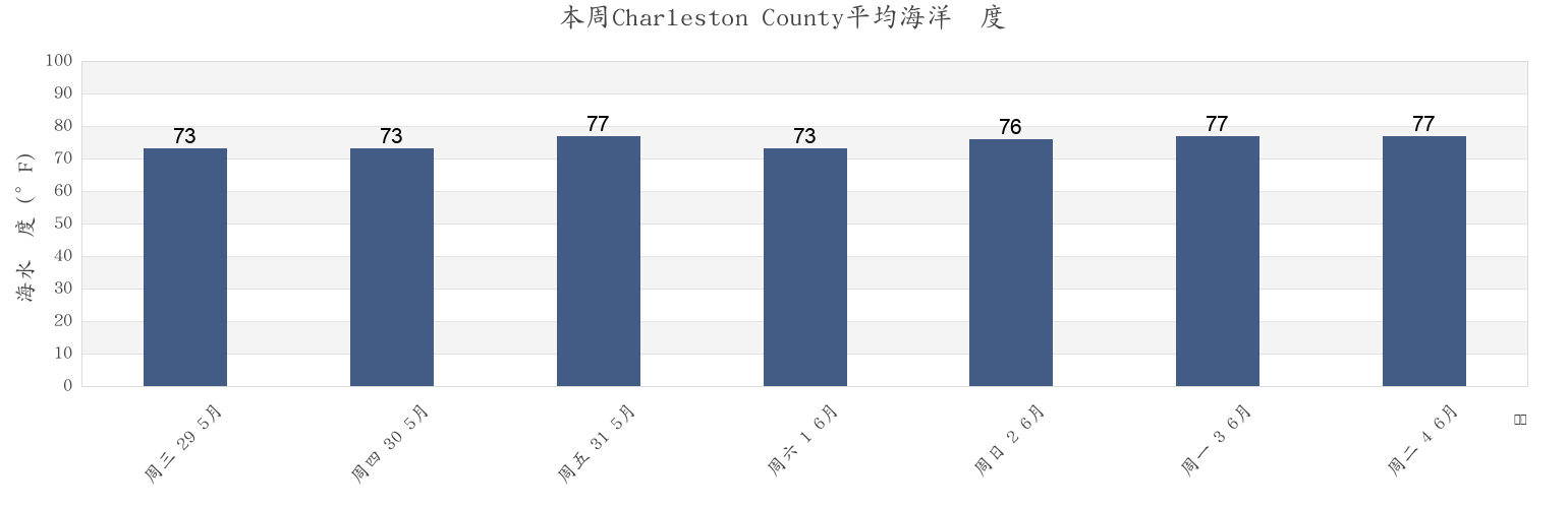
本周Charleston County海温
更多Charleston County的潮汐和海洋信息
今天
7天
天气
钓鱼时间表
地区和城市内Charleston County, South Carolina, United States
Abbapoola Creek Entrance
Folly River (North Folly Island)
Patriots Point
ACE Basin
Folly River Bridge (Flooy Island)
Pea Island
Army Depot
Folly River Bridge Flooy Island
Pennys Creek (West Entrance)
Ashley River (I-526 Bridge)
Folly River North Folly Island
Pennys Creek West Entrance
Awendaw
Fort Johnson
Pleasant Point
Battery southwest of
Fort Sumter
Plum Island
显示更多地点
Bees Ferry Bridge
Fort Sumter Range Buoy 14
Point Of Pines
Ben Sawyer Bridge
Fort Sumter Range Buoy 2
Price Creek (North Capers Island)
Ben Sawyer Bridge ICWW
Fort Sumter Range Buoy 20
Price Creek North Capers Island
Big Paradise Island
Fort Sumter Range Buoy 4
Rathall Creek entrance
Bluff Point
Fort Sumter Range Buoy 8
Rebellion Reach 0.8 n.mi. N. of Ft. Sumter
Botany Bay Island
Ft. Sumter 0.6 n.mi. NW of
Remley Point 0.2 mile northwest of
Bowen Island
Goose Creek entrance
Rockville (Bohicket Creek)
Breach Inlet (Isle Of Palms)
Goshen Point SE of Wadmalaw River
Rockville Bohicket Creek
Breach Inlet Isle Of Palms
Goshen Point south of Wadmalaw River
S.C.L. RR. bridge 0.1 mile below
Buck Hall (Awendaw Creek)
Hamlin Creek (Isle Of Palms)
S.C.L. RR. bridge 1.5 miles above
Buck Hall Awendaw Creek
Hamlin Sound
Sandblasters (Pennys Creek)
Buoy '19'
Harbor River Entrance
Sandblasters Pennys Creek
Buoy 19 off Nowell Creek
Ho-non-wah Boy Scout Camp (Bohicket Creek)
Seabrook Beach
Cainhoy
Hobcaw Point
Seabrook Island
Cainhoy Wando River
Hog Island Channel
Secessionville Secessionville Creek
Capers Creek South Capers Island
Hog Island Reach Buoy 12
Shem Creek
Castle Pinckney 0.4 mile south of
Hog Island Reach SW of Remley Point
Shipyard Creek (0.8 mile above entrance)
Castle Pinckney 0.6 mile southwest of
Hollywood
Shipyard Creek entrance
Charleston
Horlbeck Creek 0.2 mile above entrance
Shutes Folly Island 0.4 mile west of
Charleston (customhouse Wharf)
Horlbeck Creek 2.5 miles north of
Shutes Reach Buoy 8
Charleston Harbor (off Fort Sumter)
Horse Reach
Snake Island
Charleston Harbor Entrance
I 526 Bridge
Sol Legare Island
Charleston Hbr. ent. (between jetties)
Isle of Palms
South Ashley Bridge
Church Creek Bridge
Isle Of Palms Pier
South Capers Island
Church Flats
Jack Creek Entrance
South Chan. 0.4 mi. NW of Ft. Johnson
Clouter Creek (North Entrance)
James Island Creek (1 mi. above ent.)
South Chan. 0.8 mi. ENE of Ft. Johnson
Clouter Creek (South Entrance)
Johns Island (Church Creek)
South Channel Buoy 32
Clouter Creek North Entrance
Johns Island Airport south of
South Dewees Island (Dewees Inlet)
Clouter Creek South Entrance
Johns Island Bridge
South Dewees Island Dewees Inlet
Cosgrove Bridge
Johns Island Church Creek
South Jetty break in
Customhouse Reach
Kiawah Island
State Hwy. 7 bridge
Customhouse Reach off Customhouse
Kiawah River Bridge
Stono Inlet
Daniel Island Bend
Leadenwah Creek (3 Mi. Above Entrance)
Sullivans I. 0.7 mi. NE of Ft. Sumter
Daniel Island Reach
Limehouse Bridge
Sullivans Island
Daniel Island Reach Buoy 48
Meggett
Sullivans Island (outer Coast)
Deveaux Banks off North Edisto River entrance
Moores Landing (Sewee Bay)
The Cove (Fort Moultrie)
Drayton Bees Ferry
Moores Landing ICWW Sewee Bay
The Cove entrance on the Cove Range
Drum Island 0.2 mile above
Morris Island
The Cove Fort Moultrie
Drum Island 0.4 mile SSE of
Mount Pleasant
The Washout
Drum Island east of (bridge)
North Charleston
Town Creek 0.2 mile above bridge
Drum Island Reach off Drum I. Buoy 45
North Dewees Island (Capers Inlet)
Town Creek Lower Reach
Duck Island
North Dewees Island Capers Inlet
Wadmalaw Island Wadmalaw River entrance
Elliott Cut Entrance
North Edisto River entrance
Wando River Upper Reach Turning Basin
Elliott Cut west end
North Jetty 0.8 mile southeast of
Wappoo Creek
Filbin Creek Reach
Nowell Creek
Wappoo Creek Highway Bridge
Filbin Creek Reach 0.2 mile east of
Nowell Creek entrance
Wappoo Creek off of
Filbin Creek Reach Buoy 58
Oak Branch (Bohicket Creek)
West Marsh Island 0.1 mile east of
Five Fathom Creek Entrance
Oak Branch Bohicket Creek
Wharf Creek Entrance
Folly Beach
Ocella Creek (2 Mi. Above Entrance)
Woods Point
Folly Beach Pier
Old Capers Landing (Capers Island)
Woods Point SE of
Folly Creek (Hwy. 171 Bridge)
Old Capers Landing Santee Pass Capers Island
Woodville
Folly I. Channel N of Ft. Johnson
Ordnance Reach
Yellow House Creek
Folly Island (outer Coast)
Parker Island (Horlbeck Creek)
Yellow House Landing 1 mile NW of
Folly Reach Buoy 5
Parker Island Horlbeck Creek
Yonges Island
附近的潮汐Charleston County
James Island Creek (1 mi. above ent.)
Plum Island
Battery southwest of
Castle Pinckney 0.6 mile southwest of
Wappoo Creek off of
Charleston
South Chan. 0.4 mi. NW of Ft. Johnson
South Channel Buoy 32
Wappoo Creek Highway Bridge
Castle Pinckney 0.4 mile south of