ZH
°F
更改尺寸
Meters
Feet
度
°F
公里小时
英里/小时
节
am/pm
24-hour
您的设置已更新
改变语言
Deutsch
Español
Italiano
Nederlands
中文
English
Français
日本語
Português
今天
7天
天气
钓鱼时间表
海水温度
United States
潮汐
Massachusetts
潮汐
Dukes County
潮汐
Dukes County海水温度
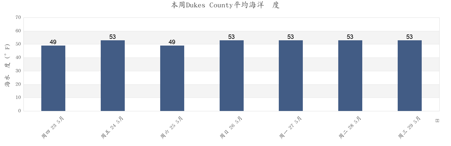
本周Dukes County海温
更多Dukes County的潮汐和海洋信息
今天
7天
天气
钓鱼时间表
地区和城市内Dukes County, Massachusetts, United States
Abels Hill
Hedge Fence-LHommedieu Shoal between
Penikese Island 0.8 mile northwest of
Bend-in-the-Road Beach
Juniper Point
Quick's Hole
Bristol Beach
Katama Bay
Quicks Hole
Canapitsit Channel
Kettle Cove
Quicks Hole (middle)
Cape Poge Light 1.4 miles west of
L'Hommedieu Shoal
Quicks Hole North side
Cape Poge Lt. 1.7 miles SSE of
Lamberts Cove
Raymond Street
显示更多地点
Cape Poge Lt. 3.2 miles northeast of
LHommedieu Shoal north of west end
Robinsons Hole 1.2 miles southeast of
Cedar Tree Neck
Lighthouse Beach
Robinsons Hole Nashuon Point
Chappaquoit Beach
Little Harbor
Round Hill Point
Chappaquoit Point
Lobsterville Beach
South Beach State Park
Chappaquoit Point West Falmouth Harbor
Long Point
South Cape Beach
Clarks Point
Lucy Vincent Beach
Squibnocket Beach
Cleveland Ledge
Martha's Vineyard GPS Buoy
Squibnocket Point
Cuttyhunk
Marthas Vineyard GPS Buoy
Surf Drive Beach
Cuttyhunk Pond entrance
Menauhant Beach
Tarpaulin Cove 1.5 miles east of
Dumpling Rocks 0.2 mile southeast of
Menemsha Beach
Uncatena Island (South Side)
East Beach
Menemsha Bight
Vineyard Haven
East Chop 1 mile north of
Menemsha Harbor Ma
Vineyard Haven Harbor
East Chop-Squash Meadow
Muskeget Channel
Waquoit Bay entrance
East Chop-Squash Meadow between
Muskeget Rock 1.3 miles southwest of
Wasque Point (Chappaquiddick Island)
Edgartown
No Man's Land
Wasque Point Chappaquiddick Island
Edgartown Great Pond
Nobska Point 1 mile southeast of
Weepecket Island south of
Falmouth Heights
Nobska Point 1.8 miles east of
West Chop 0.2 mile west of
Falmouth Heights Beach
Nomans Land
West Chop 0.8 mile north of
Felix Neck
Norton Point 0.5 mile north of
West Falmouth Harbor
Fuller Street
Norton Point Beach
West Island (west side)
Gay Head
Oak Bluffs
West Island 1 mile Southeast of
Gay Head 1.5 miles northwest of
Oceanographic Institution
West Tisbury
Gay Head 3 miles north of
Off Chilmark Pond
Woodneck Beach
Gay Head 3 miles northeast of
Off Jobs Neck Pond
Woods Hole
Great Rock Bight
Off Lake Tashmoo
Woods Hole Oceanographic Institute
Gull I. and Nashawena I. between
Old Silver Beach
Woods Hole The Strait
Hedge Fence Lighted Gong Buoy 22
Penikese Island
Hedge Fence-L'Hommedieu Shoal
Penikese Island 0.2 mile south of
附近的潮汐Dukes County
West Tisbury
Great Rock Bight
Cedar Tree Neck
Abels Hill
Lucy Vincent Beach
Lamberts Cove
Long Point
Off Chilmark Pond
Menemsha Harbor Ma
Menemsha Beach